|
|
|||||||||||||||||
| Point ID: 9612 | Downloads | Plots | Site Data | Code: 05125500 |
|
|
|||||||||||||||||
| Download | |
|---|---|
| Site Descriptor Information | Site Time Series Data |
| Link to all available data | |
| View: | Time Series | All |
| Units: | m3/s |
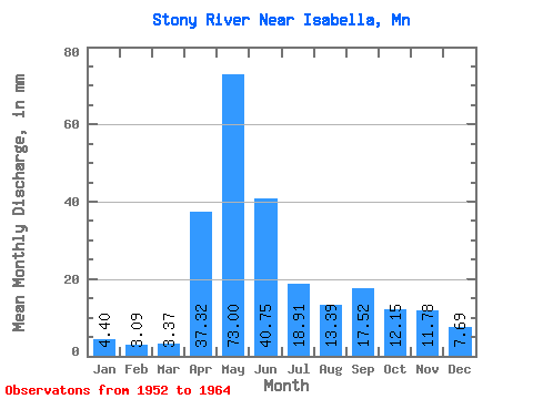
| Statistic | Jan | Feb | Mar | Apr | May | Jun | Jul | Aug | Sep | Oct | Nov | Dec | Annual |
|---|---|---|---|---|---|---|---|---|---|---|---|---|---|
| Mean | 4.40 | 3.12 | 3.37 | 37.32 | 73.00 | 40.76 | 18.91 | 13.39 | 17.52 | 12.15 | 11.78 | 7.69 | 243.43 |
| Standard Deviation | 1.26 | 1.04 | 1.22 | 21.20 | 41.88 | 17.69 | 12.68 | 10.93 | 13.25 | 6.89 | 5.65 | 2.37 | 66.53 |
| Min | 1.74 | 1.18 | 2.09 | 10.86 | 19.53 | 12.96 | 3.62 | 1.48 | 1.99 | 1.63 | 4.94 | 4.68 | 148.87 |
| Max | 6.09 | 4.54 | 6.52 | 79.15 | 153.66 | 73.09 | 41.01 | 37.06 | 46.34 | 23.50 | 21.65 | 13.14 | 347.57 |
| Coefficient of Variation | 0.28 | 0.33 | 0.36 | 0.57 | 0.57 | 0.43 | 0.67 | 0.82 | 0.76 | 0.57 | 0.48 | 0.31 | 0.27 |
 Return to R-Arctic Net Home Page