|
|
|||||||||||||||||
| Point ID: 9607 | Downloads | Plots | Site Data | Code: 05059300 |
|
|
|||||||||||||||||
| Download | |
|---|---|
| Site Descriptor Information | Site Time Series Data |
| Link to all available data | |
| View: | Time Series | All |
| Units: | m3/s |
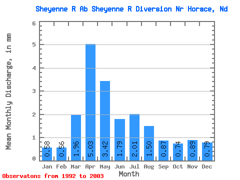
| Statistic | Jan | Feb | Mar | Apr | May | Jun | Jul | Aug | Sep | Oct | Nov | Dec | Annual |
|---|---|---|---|---|---|---|---|---|---|---|---|---|---|
| Mean | 0.58 | 0.56 | 1.96 | 5.03 | 3.42 | 1.79 | 2.01 | 1.50 | 0.86 | 0.74 | 0.89 | 0.80 | 21.39 |
| Standard Deviation | 0.21 | 0.25 | 1.42 | 3.59 | 2.75 | 0.70 | 0.98 | 1.98 | 0.64 | 0.55 | 0.58 | 0.36 | 6.59 |
| Min | 0.24 | 0.18 | 0.20 | 0.50 | 0.77 | 0.81 | 0.96 | 0.30 | 0.20 | 0.17 | 0.18 | 0.10 | 6.49 |
| Max | 0.89 | 0.91 | 4.02 | 9.50 | 9.06 | 3.03 | 3.83 | 7.36 | 1.87 | 2.23 | 1.98 | 1.42 | 28.90 |
| Coefficient of Variation | 0.37 | 0.44 | 0.73 | 0.71 | 0.80 | 0.39 | 0.49 | 1.31 | 0.74 | 0.74 | 0.65 | 0.46 | 0.31 |
 Return to R-Arctic Net Home Page