|
|
|||||||||||||||||
| Point ID: 9601 | Downloads | Plots | Site Data | Code: 05127220 |
|
|
|||||||||||||||||
| Download | |
|---|---|
| Site Descriptor Information | Site Time Series Data |
| Link to all available data | |
| View: | Time Series | All |
| Units: | m3/s |
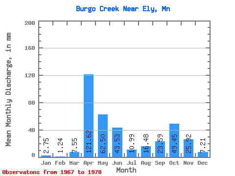
| Statistic | Jan | Feb | Mar | Apr | May | Jun | Jul | Aug | Sep | Oct | Nov | Dec | Annual |
|---|---|---|---|---|---|---|---|---|---|---|---|---|---|
| Mean | 2.82 | 1.40 | 7.55 | 121.73 | 62.56 | 43.43 | 10.81 | 16.34 | 23.51 | 49.40 | 26.07 | 7.21 | 391.48 |
| Standard Deviation | 2.00 | 0.96 | 11.09 | 51.74 | 40.85 | 41.97 | 9.74 | 24.27 | 42.00 | 56.50 | 25.91 | 5.55 | 159.44 |
| Min | 0.00 | 0.00 | 0.29 | 26.34 | 11.55 | 0.90 | 0.00 | 0.17 | 0.01 | 0.31 | 0.00 | 0.00 | 192.32 |
| Max | 5.97 | 3.04 | 35.36 | 198.08 | 164.58 | 147.66 | 36.74 | 80.47 | 149.60 | 165.39 | 80.14 | 16.41 | 716.42 |
| Coefficient of Variation | 0.71 | 0.69 | 1.47 | 0.42 | 0.65 | 0.97 | 0.90 | 1.48 | 1.79 | 1.14 | 0.99 | 0.77 | 0.41 |
 Return to R-Arctic Net Home Page