|
|
|||||||||||||||||
| Point ID: 9600 | Downloads | Plots | Site Data | Code: 05127215 |
|
|
|||||||||||||||||
| Download | |
|---|---|
| Site Descriptor Information | Site Time Series Data |
| Link to all available data | |
| View: | Time Series | All |
| Units: | m3/s |
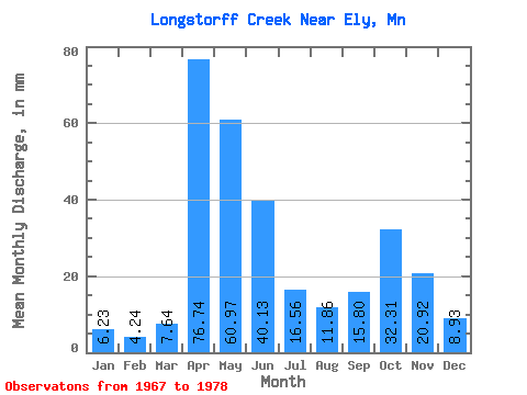
| Statistic | Jan | Feb | Mar | Apr | May | Jun | Jul | Aug | Sep | Oct | Nov | Dec | Annual |
|---|---|---|---|---|---|---|---|---|---|---|---|---|---|
| Mean | 6.25 | 4.31 | 7.61 | 76.69 | 60.94 | 40.14 | 16.55 | 11.87 | 15.82 | 32.25 | 20.87 | 8.90 | 315.94 |
| Standard Deviation | 4.27 | 3.26 | 4.32 | 35.56 | 36.11 | 32.03 | 10.52 | 13.11 | 22.66 | 38.00 | 21.42 | 7.08 | 107.51 |
| Min | 0.00 | 0.00 | 2.58 | 7.61 | 14.71 | 5.36 | 4.46 | 1.16 | 0.04 | 0.80 | 0.92 | 0.04 | 149.96 |
| Max | 15.39 | 11.35 | 17.84 | 137.69 | 143.98 | 112.92 | 40.88 | 47.19 | 74.73 | 111.97 | 56.66 | 19.18 | 508.72 |
| Coefficient of Variation | 0.68 | 0.76 | 0.57 | 0.46 | 0.59 | 0.80 | 0.64 | 1.10 | 1.43 | 1.18 | 1.03 | 0.80 | 0.34 |
 Return to R-Arctic Net Home Page