|
|
|||||||||||||||||
| Point ID: 9587 | Downloads | Plots | Site Data | Code: 05055520 |
|
|
|||||||||||||||||
| Download | |
|---|---|
| Site Descriptor Information | Site Time Series Data |
| Link to all available data | |
| View: | Time Series | All |
| Units: | m3/s |
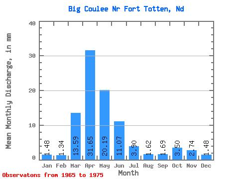
| Statistic | Jan | Feb | Mar | Apr | May | Jun | Jul | Aug | Sep | Oct | Nov | Dec | Annual |
|---|---|---|---|---|---|---|---|---|---|---|---|---|---|
| Mean | 0.49 | 0.43 | 4.51 | 10.48 | 6.67 | 3.67 | 1.28 | 0.55 | 0.57 | 1.17 | 0.91 | 0.50 | 29.92 |
| Standard Deviation | 0.14 | 0.13 | 4.41 | 7.92 | 4.57 | 1.74 | 1.03 | 0.18 | 0.21 | 0.82 | 0.38 | 0.14 | 9.53 |
| Min | 0.27 | 0.15 | 0.66 | 1.69 | 3.20 | 1.36 | 0.40 | 0.33 | 0.31 | 0.58 | 0.53 | 0.26 | 13.27 |
| Max | 0.68 | 0.60 | 12.44 | 23.40 | 18.91 | 7.24 | 3.74 | 0.89 | 0.98 | 2.76 | 1.87 | 0.71 | 42.74 |
| Coefficient of Variation | 0.29 | 0.31 | 0.98 | 0.76 | 0.69 | 0.47 | 0.81 | 0.33 | 0.37 | 0.70 | 0.41 | 0.28 | 0.32 |
 Return to R-Arctic Net Home Page