|
|
|||||||||||||||||
| Point ID: 9584 | Downloads | Plots | Site Data | Code: 05131448 |
|
|
|||||||||||||||||
| Download | |
|---|---|
| Site Descriptor Information | Site Time Series Data |
| Link to all available data | |
| View: | Time Series | All |
| Units: | m3/s |
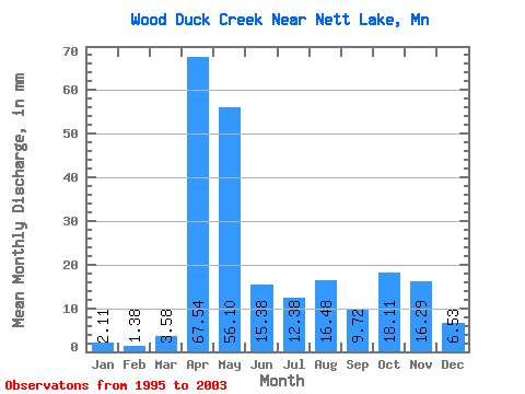
| Statistic | Jan | Feb | Mar | Apr | May | Jun | Jul | Aug | Sep | Oct | Nov | Dec | Annual |
|---|---|---|---|---|---|---|---|---|---|---|---|---|---|
| Mean | 2.12 | 1.39 | 3.59 | 67.55 | 56.09 | 15.37 | 12.39 | 16.49 | 9.73 | 18.10 | 16.29 | 6.55 | 239.13 |
| Standard Deviation | 2.04 | 1.45 | 2.96 | 47.13 | 44.56 | 15.75 | 10.39 | 25.72 | 14.95 | 19.01 | 13.63 | 5.40 | 121.48 |
| Min | 0.10 | 0.00 | 0.43 | 6.32 | 10.93 | 6.04 | 3.41 | 0.74 | 0.04 | 1.99 | 2.04 | 0.59 | 102.38 |
| Max | 5.69 | 3.87 | 10.04 | 132.01 | 124.75 | 52.39 | 29.93 | 69.68 | 42.80 | 60.17 | 38.26 | 17.08 | 399.29 |
| Coefficient of Variation | 0.96 | 1.04 | 0.82 | 0.70 | 0.79 | 1.02 | 0.84 | 1.56 | 1.54 | 1.05 | 0.84 | 0.82 | 0.51 |
 Return to R-Arctic Net Home Page