|
|
|||||||||||||||||
| Point ID: 9578 | Downloads | Plots | Site Data | Code: 05092500 |
|
|
|||||||||||||||||
| Download | |
|---|---|
| Site Descriptor Information | Site Time Series Data |
| Link to all available data | |
| View: | Time Series | All |
| Units: | m3/s |
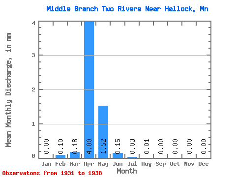
| Statistic | Jan | Feb | Mar | Apr | May | Jun | Jul | Aug | Sep | Oct | Nov | Dec | Annual |
|---|---|---|---|---|---|---|---|---|---|---|---|---|---|
| Mean | 0.00 | 0.10 | 0.18 | 4.00 | 1.51 | 0.15 | 0.03 | 0.01 | 0.00 | 0.00 | 0.00 | 0.00 | 7.42 |
| Standard Deviation | 0.00 | 0.27 | 0.31 | 7.49 | 2.54 | 0.17 | 0.06 | 0.02 | 0.00 | 0.00 | 0.00 | 0.00 | 10.16 |
| Min | 0.00 | 0.00 | 0.00 | 0.13 | 0.01 | 0.01 | 0.00 | 0.00 | 0.00 | 0.00 | 0.00 | 0.00 | 0.24 |
| Max | 0.00 | 0.70 | 0.81 | 22.35 | 7.42 | 0.47 | 0.16 | 0.07 | 0.00 | 0.00 | 0.00 | 0.00 | 26.53 |
| Coefficient of Variation | 2.65 | 1.69 | 1.87 | 1.68 | 1.18 | 1.87 | 2.83 | 1.37 |
 Return to R-Arctic Net Home Page