|
|
|||||||||||||||||
| Point ID: 9556 | Downloads | Plots | Site Data | Code: 05060570 |
|
|
|||||||||||||||||
| Download | |
|---|---|
| Site Descriptor Information | Site Time Series Data |
| Link to all available data | |
| View: | Time Series | All |
| Units: | m3/s |
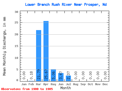
| Statistic | Jan | Feb | Mar | Apr | May | Jun | Jul | Aug | Sep | Oct | Nov | Dec | Annual |
|---|---|---|---|---|---|---|---|---|---|---|---|---|---|
| Mean | 0.00 | 0.18 | 21.77 | 25.68 | 5.05 | 3.47 | 2.37 | 0.00 | 0.00 | 0.00 | 0.00 | 0.00 | |
| Standard Deviation | 29.17 | 48.81 | 10.87 | 4.21 | 5.28 | 0.00 | |||||||
| Min | 0.00 | 0.18 | 0.33 | 0.00 | 0.03 | 0.00 | 0.00 | 0.00 | 0.00 | 0.00 | 0.00 | 0.00 | |
| Max | 0.00 | 0.18 | 72.91 | 112.66 | 24.49 | 9.06 | 11.82 | 0.00 | 0.00 | 0.00 | 0.00 | 0.00 | |
| Coefficient of Variation | 1.34 | 1.90 | 2.15 | 1.21 | 2.23 |
 Return to R-Arctic Net Home Page