|
|
|||||||||||||||||
| Point ID: 9526 | Downloads | Plots | Site Data | Code: 15276570 |
|
|
|||||||||||||||||
| Download | |
|---|---|
| Site Descriptor Information | Site Time Series Data |
| Link to all available data | |
| View: | Time Series | All |
| Units: | m3/s |
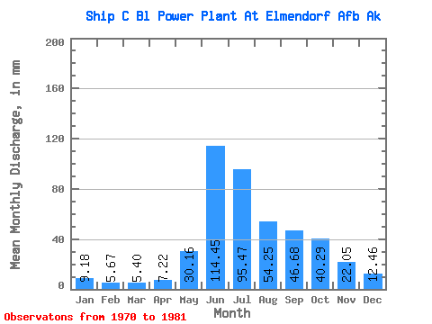
| Statistic | Jan | Feb | Mar | Apr | May | Jun | Jul | Aug | Sep | Oct | Nov | Dec | Annual |
|---|---|---|---|---|---|---|---|---|---|---|---|---|---|
| Mean | 9.18 | 5.72 | 5.40 | 7.21 | 30.16 | 114.44 | 95.46 | 54.25 | 46.68 | 40.28 | 22.05 | 12.46 | 443.21 |
| Standard Deviation | 4.62 | 1.40 | 0.96 | 3.21 | 13.06 | 46.02 | 41.69 | 32.44 | 16.27 | 19.89 | 9.87 | 4.91 | 157.17 |
| Min | 5.16 | 3.99 | 3.86 | 3.17 | 9.81 | 68.92 | 51.77 | 24.48 | 22.23 | 17.57 | 9.40 | 6.94 | 282.94 |
| Max | 20.15 | 8.59 | 7.21 | 14.63 | 55.76 | 221.92 | 193.62 | 117.37 | 75.08 | 72.69 | 42.07 | 20.74 | 796.78 |
| Coefficient of Variation | 0.50 | 0.24 | 0.18 | 0.45 | 0.43 | 0.40 | 0.44 | 0.60 | 0.35 | 0.49 | 0.45 | 0.39 | 0.35 |
 Return to R-Arctic Net Home Page