|
|
|||||||||||||||||
| Point ID: 9524 | Downloads | Plots | Site Data | Code: 15294005 |
|
|
|||||||||||||||||
| Download | |
|---|---|
| Site Descriptor Information | Site Time Series Data |
| Link to all available data | |
| View: | Time Series | All |
| Units: | m3/s |
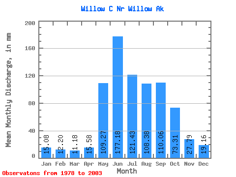
| Statistic | Jan | Feb | Mar | Apr | May | Jun | Jul | Aug | Sep | Oct | Nov | Dec | Annual |
|---|---|---|---|---|---|---|---|---|---|---|---|---|---|
| Mean | 15.08 | 12.31 | 11.18 | 15.58 | 109.26 | 177.18 | 121.41 | 108.36 | 110.06 | 73.29 | 27.79 | 19.16 | 830.78 |
| Standard Deviation | 3.20 | 3.08 | 2.48 | 6.25 | 55.44 | 54.98 | 51.28 | 46.64 | 49.82 | 45.59 | 12.01 | 5.22 | 140.85 |
| Min | 10.08 | 8.50 | 5.94 | 7.82 | 57.94 | 82.69 | 54.76 | 54.15 | 44.18 | 31.18 | 13.91 | 10.11 | 583.87 |
| Max | 19.80 | 21.58 | 17.20 | 34.94 | 278.31 | 256.10 | 227.09 | 226.78 | 200.93 | 211.23 | 62.16 | 26.82 | 1080.09 |
| Coefficient of Variation | 0.21 | 0.25 | 0.22 | 0.40 | 0.51 | 0.31 | 0.42 | 0.43 | 0.45 | 0.62 | 0.43 | 0.27 | 0.17 |
 Return to R-Arctic Net Home Page