|
|
|||||||||||||||||
| Point ID: 9513 | Downloads | Plots | Site Data | Code: 15282000 |
|
|
|||||||||||||||||
| Download | |
|---|---|
| Site Descriptor Information | Site Time Series Data |
| Link to all available data | |
| View: | Time Series | All |
| Units: | m3/s |
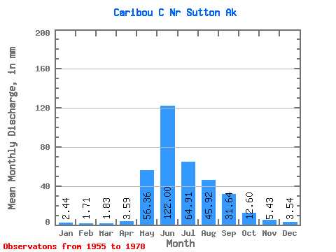
| Statistic | Jan | Feb | Mar | Apr | May | Jun | Jul | Aug | Sep | Oct | Nov | Dec | Annual |
|---|---|---|---|---|---|---|---|---|---|---|---|---|---|
| Mean | 2.44 | 1.73 | 1.83 | 3.60 | 56.35 | 122.00 | 64.90 | 45.91 | 31.64 | 12.59 | 5.43 | 3.54 | 359.07 |
| Standard Deviation | 1.56 | 1.09 | 1.17 | 2.16 | 32.03 | 54.27 | 25.80 | 23.05 | 15.81 | 3.45 | 2.30 | 1.86 | 102.70 |
| Min | 0.10 | 0.09 | 0.05 | 0.23 | 10.63 | 27.70 | 13.61 | 16.93 | 13.77 | 7.75 | 1.61 | 0.32 | 163.36 |
| Max | 4.83 | 3.23 | 3.24 | 9.52 | 166.06 | 256.87 | 129.20 | 94.19 | 72.76 | 21.25 | 11.34 | 7.16 | 573.32 |
| Coefficient of Variation | 0.64 | 0.63 | 0.64 | 0.60 | 0.57 | 0.45 | 0.40 | 0.50 | 0.50 | 0.27 | 0.42 | 0.53 | 0.29 |
 Return to R-Arctic Net Home Page