|
|
|||||||||||||||||
| Point ID: 9512 | Downloads | Plots | Site Data | Code: 15281500 |
|
|
|||||||||||||||||
| Download | |
|---|---|
| Site Descriptor Information | Site Time Series Data |
| Link to all available data | |
| View: | Time Series | All |
| Units: | m3/s |
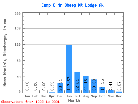
| Statistic | Jan | Feb | Mar | Apr | May | Jun | Jul | Aug | Sep | Oct | Nov | Dec | Annual |
|---|---|---|---|---|---|---|---|---|---|---|---|---|---|
| Mean | 0.27 | 0.00 | 0.00 | 0.48 | 23.79 | 117.93 | 52.60 | 40.77 | 32.99 | 14.75 | 7.08 | 2.69 | 271.89 |
| Standard Deviation | 0.47 | 0.00 | 0.00 | 0.61 | 13.91 | 86.88 | 24.60 | 30.63 | 22.57 | 8.88 | 7.14 | 4.22 | 155.45 |
| Min | 0.00 | 0.00 | 0.00 | 0.00 | 6.76 | 14.66 | 11.48 | 10.80 | 11.76 | 4.63 | 0.00 | 0.00 | 70.13 |
| Max | 1.14 | 0.00 | 0.00 | 1.54 | 41.80 | 224.95 | 80.34 | 96.88 | 68.97 | 30.39 | 17.03 | 10.52 | 448.53 |
| Coefficient of Variation | 1.72 | 1.29 | 0.58 | 0.74 | 0.47 | 0.75 | 0.68 | 0.60 | 1.01 | 1.57 | 0.57 |
 Return to R-Arctic Net Home Page