|
|
|||||||||||||||||
| Point ID: 9506 | Downloads | Plots | Site Data | Code: 15277410 |
|
|
|||||||||||||||||
| Download | |
|---|---|
| Site Descriptor Information | Site Time Series Data |
| Link to all available data | |
| View: | Time Series | All |
| Units: | m3/s |
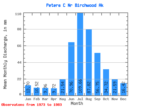
| Statistic | Jan | Feb | Mar | Apr | May | Jun | Jul | Aug | Sep | Oct | Nov | Dec | Annual |
|---|---|---|---|---|---|---|---|---|---|---|---|---|---|
| Mean | 13.69 | 10.62 | 9.97 | 9.72 | 21.55 | 70.95 | 109.64 | 87.80 | 56.76 | 34.71 | 21.59 | 16.42 | 472.25 |
| Standard Deviation | 2.99 | 2.50 | 2.10 | 2.04 | 7.85 | 19.68 | 35.62 | 29.87 | 16.49 | 9.57 | 6.00 | 3.57 | 107.89 |
| Min | 9.73 | 7.74 | 8.31 | 6.98 | 12.49 | 47.96 | 68.36 | 56.62 | 41.48 | 23.10 | 13.45 | 11.46 | 322.63 |
| Max | 18.91 | 15.19 | 15.28 | 13.29 | 37.40 | 101.35 | 183.70 | 143.34 | 98.55 | 55.26 | 30.94 | 22.96 | 659.52 |
| Coefficient of Variation | 0.22 | 0.24 | 0.21 | 0.21 | 0.36 | 0.28 | 0.33 | 0.34 | 0.29 | 0.28 | 0.28 | 0.22 | 0.23 |
 Return to R-Arctic Net Home Page