|
|
|||||||||||||||||
| Point ID: 9486 | Downloads | Plots | Site Data | Code: 15294900 |
|
|
|||||||||||||||||
| Download | |
|---|---|
| Site Descriptor Information | Site Time Series Data |
| Link to all available data | |
| View: | Time Series | All |
| Units: | m3/s |
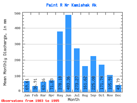
| Statistic | Jan | Feb | Mar | Apr | May | Jun | Jul | Aug | Sep | Oct | Nov | Dec | Annual |
|---|---|---|---|---|---|---|---|---|---|---|---|---|---|
| Mean | 69.60 | 37.23 | 63.15 | 71.83 | 378.13 | 483.37 | 273.23 | 161.59 | 225.08 | 171.72 | 105.91 | 43.78 | 2035.52 |
| Standard Deviation | 84.03 | 34.76 | 107.56 | 76.92 | 142.77 | 59.00 | 111.65 | 62.80 | 145.26 | 51.64 | 91.28 | 31.45 | 380.22 |
| Min | 16.50 | 12.36 | 7.83 | 9.68 | 224.92 | 415.26 | 177.99 | 97.41 | 48.31 | 82.09 | 26.87 | 12.81 | 1485.87 |
| Max | 234.53 | 113.09 | 281.90 | 232.68 | 665.90 | 570.38 | 459.39 | 273.42 | 489.11 | 224.66 | 260.18 | 83.73 | 2347.03 |
| Coefficient of Variation | 1.21 | 0.93 | 1.70 | 1.07 | 0.38 | 0.12 | 0.41 | 0.39 | 0.65 | 0.30 | 0.86 | 0.72 | 0.19 |
 Return to R-Arctic Net Home Page