|
|
|||||||||||||||||
| Point ID: 9485 | Downloads | Plots | Site Data | Code: 15294700 |
|
|
|||||||||||||||||
| Download | |
|---|---|
| Site Descriptor Information | Site Time Series Data |
| Link to all available data | |
| View: | Time Series | All |
| Units: | m3/s |
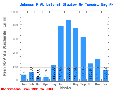
| Statistic | Jan | Feb | Mar | Apr | May | Jun | Jul | Aug | Sep | Oct | Nov | Dec | Annual |
|---|---|---|---|---|---|---|---|---|---|---|---|---|---|
| Mean | 95.41 | 131.95 | 59.33 | 62.73 | 225.80 | 787.90 | 868.45 | 753.97 | 633.07 | 251.92 | 317.08 | 163.08 | |
| Standard Deviation | 116.16 | 141.49 | 217.32 | 182.16 | 396.29 | 201.09 | 257.32 | ||||||
| Min | 95.41 | 131.95 | 59.33 | 62.73 | 90.63 | 638.24 | 583.95 | 475.18 | 222.90 | 73.92 | 135.13 | 163.08 | |
| Max | 95.41 | 131.95 | 59.33 | 62.73 | 409.61 | 1074.74 | 1268.96 | 1009.58 | 1542.18 | 641.88 | 499.03 | 163.08 | |
| Coefficient of Variation | 0.51 | 0.18 | 0.25 | 0.24 | 0.63 | 0.80 | 0.81 |
 Return to R-Arctic Net Home Page