|
|
|||||||||||||||||
| Point ID: 9478 | Downloads | Plots | Site Data | Code: 15240000 |
|
|
|||||||||||||||||
| Download | |
|---|---|
| Site Descriptor Information | Site Time Series Data |
| Link to all available data | |
| View: | Time Series | All |
| Units: | m3/s |
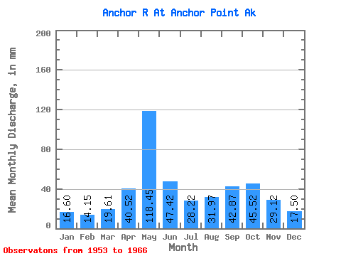
| Statistic | Jan | Feb | Mar | Apr | May | Jun | Jul | Aug | Sep | Oct | Nov | Dec | Annual |
|---|---|---|---|---|---|---|---|---|---|---|---|---|---|
| Mean | 16.60 | 14.27 | 19.61 | 40.52 | 118.44 | 47.42 | 28.21 | 31.96 | 42.87 | 45.51 | 29.12 | 17.50 | 454.05 |
| Standard Deviation | 8.06 | 7.12 | 20.92 | 19.16 | 28.14 | 27.18 | 9.62 | 9.99 | 18.44 | 15.88 | 24.24 | 6.88 | 62.06 |
| Min | 6.48 | 5.90 | 7.36 | 17.55 | 61.34 | 16.47 | 10.66 | 13.75 | 16.11 | 25.52 | 11.18 | 6.46 | 389.02 |
| Max | 36.78 | 33.64 | 88.19 | 74.07 | 169.99 | 101.36 | 47.42 | 49.51 | 75.15 | 79.16 | 104.35 | 33.62 | 566.59 |
| Coefficient of Variation | 0.49 | 0.50 | 1.07 | 0.47 | 0.24 | 0.57 | 0.34 | 0.31 | 0.43 | 0.35 | 0.83 | 0.39 | 0.14 |
 Return to R-Arctic Net Home Page