|
|
|||||||||||||||||
| Point ID: 9471 | Downloads | Plots | Site Data | Code: 15246000 |
|
|
|||||||||||||||||
| Download | |
|---|---|
| Site Descriptor Information | Site Time Series Data |
| Link to all available data | |
| View: | Time Series | All |
| Units: | m3/s |
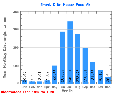
| Statistic | Jan | Feb | Mar | Apr | May | Jun | Jul | Aug | Sep | Oct | Nov | Dec | Annual |
|---|---|---|---|---|---|---|---|---|---|---|---|---|---|
| Mean | 20.47 | 14.05 | 12.99 | 19.68 | 100.65 | 287.27 | 342.86 | 273.70 | 196.60 | 121.66 | 76.16 | 36.93 | 1488.35 |
| Standard Deviation | 8.87 | 5.63 | 3.85 | 10.91 | 43.45 | 114.76 | 66.68 | 35.86 | 85.29 | 60.08 | 50.02 | 23.51 | 270.03 |
| Min | 9.91 | 7.45 | 9.03 | 9.29 | 43.80 | 172.37 | 237.49 | 215.37 | 99.47 | 42.81 | 21.32 | 13.92 | 1154.34 |
| Max | 38.22 | 26.83 | 20.14 | 42.05 | 186.13 | 595.12 | 471.14 | 339.84 | 362.13 | 223.12 | 168.44 | 82.41 | 2138.24 |
| Coefficient of Variation | 0.43 | 0.40 | 0.30 | 0.55 | 0.43 | 0.40 | 0.19 | 0.13 | 0.43 | 0.49 | 0.66 | 0.64 | 0.18 |
 Return to R-Arctic Net Home Page