|
|
|||||||||||||||||
| Point ID: 9457 | Downloads | Plots | Site Data | Code: 15239000 |
|
|
|||||||||||||||||
| Download | |
|---|---|
| Site Descriptor Information | Site Time Series Data |
| Link to all available data | |
| View: | Time Series | All |
| Units: | m3/s |
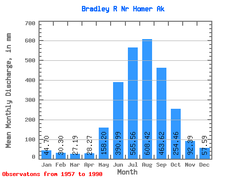
| Statistic | Jan | Feb | Mar | Apr | May | Jun | Jul | Aug | Sep | Oct | Nov | Dec | Annual |
|---|---|---|---|---|---|---|---|---|---|---|---|---|---|
| Mean | 44.69 | 30.57 | 27.19 | 28.27 | 158.17 | 390.99 | 565.47 | 608.33 | 463.62 | 254.42 | 92.38 | 57.57 | 2677.97 |
| Standard Deviation | 35.63 | 25.66 | 21.85 | 25.80 | 81.87 | 95.71 | 105.29 | 171.57 | 206.84 | 170.85 | 58.31 | 40.84 | 524.30 |
| Min | 16.53 | 9.48 | 8.92 | 8.35 | 45.36 | 261.26 | 411.39 | 342.61 | 154.42 | 83.51 | 32.19 | 19.03 | 1753.06 |
| Max | 169.97 | 145.48 | 92.93 | 156.56 | 411.51 | 685.87 | 862.82 | 1069.23 | 898.90 | 797.85 | 253.34 | 206.67 | 3708.25 |
| Coefficient of Variation | 0.80 | 0.84 | 0.80 | 0.91 | 0.52 | 0.24 | 0.19 | 0.28 | 0.45 | 0.67 | 0.63 | 0.71 | 0.20 |
 Return to R-Arctic Net Home Page