|
|
|||||||||||||||||
| Point ID: 9454 | Downloads | Plots | Site Data | Code: 15273050 |
|
|
|||||||||||||||||
| Download | |
|---|---|
| Site Descriptor Information | Site Time Series Data |
| Link to all available data | |
| View: | Time Series | All |
| Units: | m3/s |
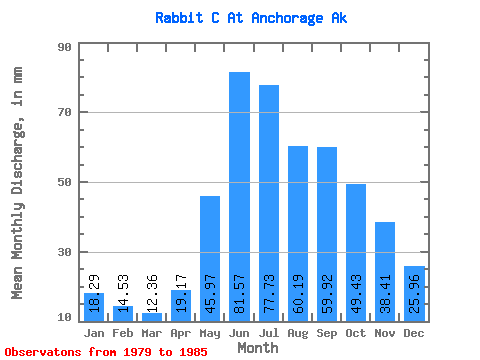
| Statistic | Jan | Feb | Mar | Apr | May | Jun | Jul | Aug | Sep | Oct | Nov | Dec | Annual |
|---|---|---|---|---|---|---|---|---|---|---|---|---|---|
| Mean | 18.29 | 14.65 | 12.37 | 19.19 | 45.97 | 81.54 | 77.70 | 60.21 | 59.90 | 49.41 | 38.40 | 25.93 | 392.96 |
| Standard Deviation | 4.15 | 2.09 | 1.65 | 8.02 | 9.88 | 26.25 | 28.49 | 27.17 | 24.08 | 6.10 | 14.40 | 10.22 | |
| Min | 14.43 | 12.84 | 10.84 | 11.89 | 34.07 | 60.40 | 43.55 | 36.18 | 35.55 | 42.43 | 28.56 | 19.29 | 392.96 |
| Max | 22.69 | 16.93 | 14.11 | 27.77 | 57.38 | 117.09 | 113.19 | 96.02 | 88.78 | 53.72 | 54.93 | 37.70 | 392.96 |
| Coefficient of Variation | 0.23 | 0.14 | 0.13 | 0.42 | 0.21 | 0.32 | 0.37 | 0.45 | 0.40 | 0.12 | 0.38 | 0.39 |
 Return to R-Arctic Net Home Page