|
|
|||||||||||||||||
| Point ID: 9428 | Downloads | Plots | Site Data | Code: 15565235 |
|
|
|||||||||||||||||
| Download | |
|---|---|
| Site Descriptor Information | Site Time Series Data |
| Link to all available data | |
| View: | Time Series | All |
| Units: | m3/s |
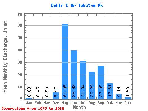
| Statistic | Jan | Feb | Mar | Apr | May | Jun | Jul | Aug | Sep | Oct | Nov | Dec | Annual |
|---|---|---|---|---|---|---|---|---|---|---|---|---|---|
| Mean | 0.82 | 0.53 | 0.57 | 5.50 | 61.12 | 39.94 | 30.91 | 22.34 | 26.98 | 12.86 | 4.21 | 1.46 | 185.65 |
| Standard Deviation | 1.05 | 0.91 | 1.01 | 4.54 | 49.92 | 14.48 | 15.89 | 13.89 | 11.81 | 6.76 | 3.40 | 1.24 | 63.62 |
| Min | 0.00 | 0.00 | 0.00 | 0.21 | 11.95 | 28.01 | 9.98 | 6.75 | 6.93 | 3.23 | 1.42 | 0.43 | 122.91 |
| Max | 2.59 | 2.12 | 2.33 | 12.09 | 144.89 | 64.39 | 49.40 | 44.52 | 38.97 | 19.66 | 9.94 | 3.51 | 264.44 |
| Coefficient of Variation | 1.27 | 1.73 | 1.78 | 0.83 | 0.82 | 0.36 | 0.51 | 0.62 | 0.44 | 0.53 | 0.81 | 0.85 | 0.34 |
 Return to R-Arctic Net Home Page