|
|
|||||||||||||||||
| Point ID: 9420 | Downloads | Plots | Site Data | Code: 15518350 |
|
|
|||||||||||||||||
| Download | |
|---|---|
| Site Descriptor Information | Site Time Series Data |
| Link to all available data | |
| View: | Time Series | All |
| Units: | m3/s |
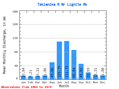
| Statistic | Jan | Feb | Mar | Apr | May | Jun | Jul | Aug | Sep | Oct | Nov | Dec | Annual |
|---|---|---|---|---|---|---|---|---|---|---|---|---|---|
| Mean | 10.84 | 9.29 | 10.31 | 11.86 | 49.85 | 109.79 | 111.72 | 85.83 | 45.80 | 20.59 | 13.31 | 11.88 | 499.92 |
| Standard Deviation | 2.62 | 2.16 | 2.14 | 3.00 | 21.48 | 57.57 | 58.02 | 34.74 | 15.80 | 4.53 | 3.87 | 3.15 | 167.45 |
| Min | 5.38 | 4.90 | 7.52 | 8.12 | 24.65 | 59.99 | 52.97 | 62.10 | 27.85 | 14.84 | 8.68 | 5.67 | 350.04 |
| Max | 13.74 | 11.98 | 14.34 | 18.31 | 89.03 | 235.60 | 264.09 | 175.87 | 78.78 | 29.45 | 20.82 | 15.54 | 901.79 |
| Coefficient of Variation | 0.24 | 0.23 | 0.21 | 0.25 | 0.43 | 0.52 | 0.52 | 0.41 | 0.34 | 0.22 | 0.29 | 0.27 | 0.34 |
 Return to R-Arctic Net Home Page