|
|
|||||||||||||||||
| Point ID: 9412 | Downloads | Plots | Site Data | Code: 15478040 |
|
|
|||||||||||||||||
| Download | |
|---|---|
| Site Descriptor Information | Site Time Series Data |
| Link to all available data | |
| View: | Time Series | All |
| Units: | m3/s |
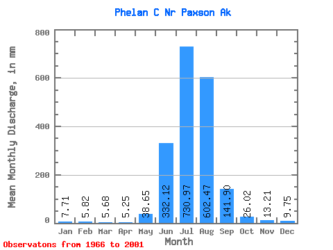
| Statistic | Jan | Feb | Mar | Apr | May | Jun | Jul | Aug | Sep | Oct | Nov | Dec | Annual |
|---|---|---|---|---|---|---|---|---|---|---|---|---|---|
| Mean | 7.71 | 5.87 | 5.67 | 5.21 | 38.65 | 332.15 | 730.84 | 602.37 | 141.89 | 26.03 | 13.17 | 9.75 | 1906.27 |
| Standard Deviation | 2.74 | 2.29 | 2.27 | 2.02 | 27.78 | 108.95 | 177.10 | 234.41 | 81.38 | 7.92 | 4.25 | 3.28 | 416.44 |
| Min | 3.56 | 2.16 | 2.37 | 2.30 | 5.75 | 169.33 | 434.50 | 176.74 | 33.26 | 13.32 | 5.82 | 4.83 | 1190.42 |
| Max | 12.80 | 9.81 | 9.58 | 9.27 | 115.57 | 574.79 | 1103.74 | 987.07 | 299.09 | 41.64 | 22.22 | 16.49 | 2590.41 |
| Coefficient of Variation | 0.35 | 0.39 | 0.40 | 0.39 | 0.72 | 0.33 | 0.24 | 0.39 | 0.57 | 0.30 | 0.32 | 0.34 | 0.22 |
 Return to R-Arctic Net Home Page