|
|
|||||||||||||||||
| Point ID: 9391 | Downloads | Plots | Site Data | Code: 15748000 |
|
|
|||||||||||||||||
| Download | |
|---|---|
| Site Descriptor Information | Site Time Series Data |
| Link to all available data | |
| View: | Time Series | All |
| Units: | m3/s |
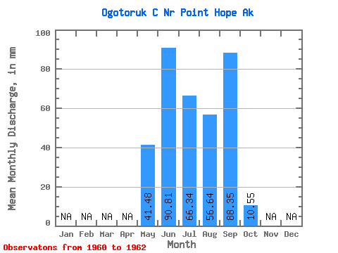
| Statistic | Jan | Feb | Mar | Apr | May | Jun | Jul | Aug | Sep | Oct | Nov | Dec | Annual |
|---|---|---|---|---|---|---|---|---|---|---|---|---|---|
| Mean | 41.46 | 90.81 | 66.33 | 56.63 | 88.34 | 10.54 | |||||||
| Standard Deviation | 34.66 | 50.83 | 15.47 | 9.07 | 60.01 | 0.36 | |||||||
| Min | 16.95 | 54.87 | 55.39 | 50.22 | 45.91 | 10.29 | |||||||
| Max | 65.97 | 126.75 | 77.27 | 63.05 | 130.78 | 10.80 | |||||||
| Coefficient of Variation | 0.84 | 0.56 | 0.23 | 0.16 | 0.68 | 0.03 |
 Return to R-Arctic Net Home Page