|
|
|||||||||||||||||
| Point ID: 9377 | Downloads | Plots | Site Data | Code: 15299900 |
|
|
|||||||||||||||||
| Download | |
|---|---|
| Site Descriptor Information | Site Time Series Data |
| Link to all available data | |
| View: | Time Series | All |
| Units: | m3/s |
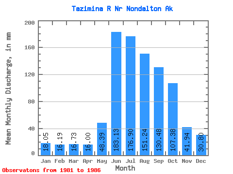
| Statistic | Jan | Feb | Mar | Apr | May | Jun | Jul | Aug | Sep | Oct | Nov | Dec | Annual |
|---|---|---|---|---|---|---|---|---|---|---|---|---|---|
| Mean | 18.05 | 16.33 | 16.73 | 16.00 | 48.38 | 183.13 | 176.87 | 151.22 | 130.49 | 107.36 | 41.94 | 30.79 | 930.72 |
| Standard Deviation | 3.75 | 4.74 | 5.71 | 2.99 | 11.44 | 32.73 | 49.22 | 49.95 | 69.24 | 54.95 | 15.98 | 19.36 | 201.58 |
| Min | 14.53 | 11.42 | 12.54 | 12.74 | 37.00 | 138.81 | 120.86 | 86.28 | 58.18 | 52.52 | 22.00 | 16.55 | 722.15 |
| Max | 22.90 | 22.92 | 26.55 | 19.59 | 65.62 | 221.66 | 241.04 | 212.24 | 229.95 | 178.86 | 60.93 | 64.14 | 1180.82 |
| Coefficient of Variation | 0.21 | 0.29 | 0.34 | 0.19 | 0.24 | 0.18 | 0.28 | 0.33 | 0.53 | 0.51 | 0.38 | 0.63 | 0.22 |
 Return to R-Arctic Net Home Page