|
|
|||||||||||||||||
| Point ID: 9355 | Downloads | Plots | Site Data | Code: 15476300 |
|
|
|||||||||||||||||
| Download | |
|---|---|
| Site Descriptor Information | Site Time Series Data |
| Link to all available data | |
| View: | Time Series | All |
| Units: | m3/s |
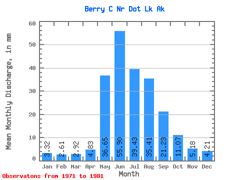
| Statistic | Jan | Feb | Mar | Apr | May | Jun | Jul | Aug | Sep | Oct | Nov | Dec | Annual |
|---|---|---|---|---|---|---|---|---|---|---|---|---|---|
| Mean | 3.32 | 2.63 | 2.93 | 4.82 | 36.65 | 55.89 | 39.43 | 35.40 | 21.23 | 11.08 | 5.18 | 4.21 | 226.10 |
| Standard Deviation | 1.64 | 1.42 | 1.61 | 2.71 | 16.07 | 24.77 | 10.73 | 11.55 | 6.02 | 4.12 | 1.84 | 1.76 | 55.12 |
| Min | 0.32 | 0.25 | 0.35 | 0.89 | 14.49 | 21.91 | 20.70 | 21.12 | 14.97 | 6.14 | 1.98 | 0.64 | 155.75 |
| Max | 5.40 | 4.50 | 4.94 | 8.54 | 62.91 | 94.73 | 63.44 | 65.52 | 35.38 | 18.34 | 7.40 | 6.47 | 351.00 |
| Coefficient of Variation | 0.49 | 0.54 | 0.55 | 0.56 | 0.44 | 0.44 | 0.27 | 0.33 | 0.28 | 0.37 | 0.35 | 0.42 | 0.24 |
 Return to R-Arctic Net Home Page