|
|
|||||||||||||||||
| Point ID: 9310 | Downloads | Plots | Site Data | Code: 15086000 |
|
|
|||||||||||||||||
| Download | |
|---|---|
| Site Descriptor Information | Site Time Series Data |
| Link to all available data | |
| View: | Time Series | All |
| Units: | m3/s |
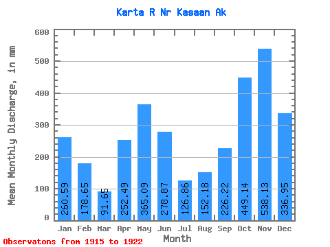
| Statistic | Jan | Feb | Mar | Apr | May | Jun | Jul | Aug | Sep | Oct | Nov | Dec | Annual |
|---|---|---|---|---|---|---|---|---|---|---|---|---|---|
| Mean | 260.55 | 180.19 | 91.63 | 252.50 | 365.04 | 278.88 | 126.83 | 152.16 | 226.23 | 449.07 | 538.13 | 336.90 | 3273.92 |
| Standard Deviation | 162.80 | 96.77 | 28.70 | 105.16 | 68.28 | 44.19 | 47.10 | 85.32 | 98.43 | 168.13 | 302.98 | 90.42 | 584.22 |
| Min | 54.10 | 43.12 | 66.38 | 146.18 | 292.15 | 206.01 | 48.84 | 41.90 | 129.87 | 198.31 | 303.34 | 227.70 | 2573.33 |
| Max | 496.95 | 357.05 | 138.51 | 395.35 | 477.70 | 333.51 | 202.96 | 270.19 | 368.55 | 664.45 | 1157.81 | 432.95 | 4124.03 |
| Coefficient of Variation | 0.62 | 0.54 | 0.31 | 0.42 | 0.19 | 0.16 | 0.37 | 0.56 | 0.43 | 0.37 | 0.56 | 0.27 | 0.18 |
 Return to R-Arctic Net Home Page