|
|
|||||||||||||||||
| Point ID: 9305 | Downloads | Plots | Site Data | Code: 15085700 |
|
|
|||||||||||||||||
| Download | |
|---|---|
| Site Descriptor Information | Site Time Series Data |
| Link to all available data | |
| View: | Time Series | All |
| Units: | m3/s |
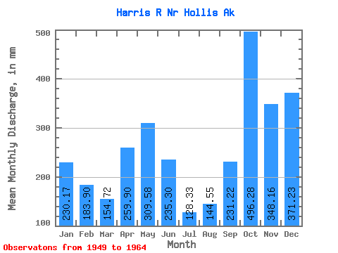
| Statistic | Jan | Feb | Mar | Apr | May | Jun | Jul | Aug | Sep | Oct | Nov | Dec | Annual |
|---|---|---|---|---|---|---|---|---|---|---|---|---|---|
| Mean | 230.14 | 185.49 | 154.69 | 259.88 | 309.54 | 235.32 | 128.30 | 144.54 | 231.21 | 496.20 | 348.15 | 371.18 | 3042.30 |
| Standard Deviation | 176.15 | 111.73 | 86.58 | 66.49 | 109.90 | 91.33 | 47.91 | 67.56 | 88.47 | 204.07 | 105.04 | 158.22 | 442.11 |
| Min | 16.33 | 23.25 | 39.79 | 141.36 | 119.38 | 48.96 | 37.20 | 38.22 | 108.17 | 170.67 | 181.73 | 48.03 | 2072.84 |
| Max | 579.91 | 416.28 | 372.17 | 392.54 | 552.91 | 411.93 | 201.34 | 254.96 | 379.40 | 923.04 | 522.04 | 621.73 | 3720.97 |
| Coefficient of Variation | 0.77 | 0.60 | 0.56 | 0.26 | 0.35 | 0.39 | 0.37 | 0.47 | 0.38 | 0.41 | 0.30 | 0.43 | 0.14 |
 Return to R-Arctic Net Home Page