|
|
|||||||||||||||||
| Point ID: 9297 | Downloads | Plots | Site Data | Code: 15072000 |
|
|
|||||||||||||||||
| Download | |
|---|---|
| Site Descriptor Information | Site Time Series Data |
| Link to all available data | |
| View: | Time Series | All |
| Units: | m3/s |
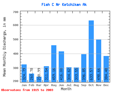
| Statistic | Jan | Feb | Mar | Apr | May | Jun | Jul | Aug | Sep | Oct | Nov | Dec | Annual |
|---|---|---|---|---|---|---|---|---|---|---|---|---|---|
| Mean | 324.73 | 263.04 | 238.97 | 311.54 | 459.10 | 416.01 | 304.57 | 303.50 | 396.84 | 633.48 | 498.66 | 384.43 | 4535.64 |
| Standard Deviation | 183.81 | 154.96 | 124.84 | 102.73 | 118.03 | 126.12 | 123.78 | 163.24 | 185.59 | 195.56 | 225.31 | 205.58 | 619.96 |
| Min | 34.56 | 31.45 | 65.14 | 114.38 | 165.70 | 125.86 | 59.55 | 46.28 | 70.69 | 216.13 | 78.76 | 76.12 | 3126.87 |
| Max | 889.32 | 784.47 | 614.26 | 578.29 | 791.21 | 674.53 | 655.58 | 699.86 | 853.62 | 1210.18 | 1560.57 | 986.11 | 5701.94 |
| Coefficient of Variation | 0.57 | 0.59 | 0.52 | 0.33 | 0.26 | 0.30 | 0.41 | 0.54 | 0.47 | 0.31 | 0.45 | 0.54 | 0.14 |
 Return to R-Arctic Net Home Page