|
|
|||||||||||||||||
| Point ID: 9286 | Downloads | Plots | Site Data | Code: 15078000 |
|
|
|||||||||||||||||
| Download | |
|---|---|
| Site Descriptor Information | Site Time Series Data |
| Link to all available data | |
| View: | Time Series | All |
| Units: | m3/s |
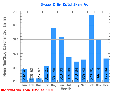
| Statistic | Jan | Feb | Mar | Apr | May | Jun | Jul | Aug | Sep | Oct | Nov | Dec | Annual |
|---|---|---|---|---|---|---|---|---|---|---|---|---|---|
| Mean | 292.43 | 227.56 | 226.42 | 311.21 | 581.31 | 518.94 | 374.77 | 343.79 | 359.42 | 669.92 | 499.13 | 365.97 | 4837.44 |
| Standard Deviation | 158.00 | 123.46 | 113.99 | 100.61 | 104.95 | 128.86 | 146.44 | 152.08 | 213.48 | 156.49 | 226.23 | 263.19 | 486.35 |
| Min | 47.77 | 28.50 | 62.91 | 115.45 | 380.07 | 291.33 | 247.32 | 62.06 | 69.11 | 405.35 | 140.66 | 137.73 | 3623.41 |
| Max | 566.39 | 418.49 | 451.01 | 531.17 | 707.34 | 822.70 | 747.55 | 593.00 | 714.92 | 900.63 | 847.51 | 1010.54 | 5753.20 |
| Coefficient of Variation | 0.54 | 0.54 | 0.50 | 0.32 | 0.18 | 0.25 | 0.39 | 0.44 | 0.59 | 0.23 | 0.45 | 0.72 | 0.10 |
 Return to R-Arctic Net Home Page