|
|
|||||||||||||||||
| Point ID: 9285 | Downloads | Plots | Site Data | Code: 15081800 |
|
|
|||||||||||||||||
| Download | |
|---|---|
| Site Descriptor Information | Site Time Series Data |
| Link to all available data | |
| View: | Time Series | All |
| Units: | m3/s |
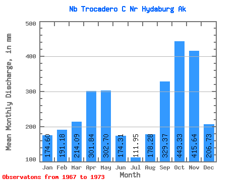
| Statistic | Jan | Feb | Mar | Apr | May | Jun | Jul | Aug | Sep | Oct | Nov | Dec | Annual |
|---|---|---|---|---|---|---|---|---|---|---|---|---|---|
| Mean | 174.58 | 192.81 | 214.05 | 301.84 | 302.64 | 174.34 | 111.90 | 178.24 | 329.37 | 443.28 | 415.61 | 206.68 | 2978.58 |
| Standard Deviation | 115.39 | 125.50 | 100.89 | 108.00 | 98.44 | 61.61 | 56.98 | 51.48 | 105.60 | 186.49 | 255.10 | 115.69 | 294.29 |
| Min | 13.67 | 9.80 | 106.71 | 186.94 | 149.38 | 97.97 | 61.22 | 83.13 | 154.06 | 243.37 | 160.13 | 79.28 | 2654.94 |
| Max | 302.99 | 304.76 | 360.37 | 502.82 | 429.69 | 258.17 | 220.53 | 237.14 | 460.62 | 796.35 | 882.56 | 367.91 | 3422.38 |
| Coefficient of Variation | 0.66 | 0.65 | 0.47 | 0.36 | 0.33 | 0.35 | 0.51 | 0.29 | 0.32 | 0.42 | 0.61 | 0.56 | 0.10 |
 Return to R-Arctic Net Home Page