|
|
|||||||||||||||||
| Point ID: 9282 | Downloads | Plots | Site Data | Code: 15028300 |
|
|
|||||||||||||||||
| Download | |
|---|---|
| Site Descriptor Information | Site Time Series Data |
| Link to all available data | |
| View: | Time Series | All |
| Units: | m3/s |
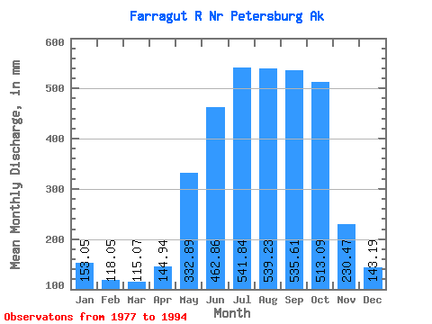
| Statistic | Jan | Feb | Mar | Apr | May | Jun | Jul | Aug | Sep | Oct | Nov | Dec | Annual |
|---|---|---|---|---|---|---|---|---|---|---|---|---|---|
| Mean | 153.02 | 119.06 | 115.05 | 144.94 | 332.84 | 462.86 | 541.76 | 539.15 | 535.61 | 513.02 | 230.47 | 143.17 | 3828.82 |
| Standard Deviation | 99.85 | 77.43 | 65.27 | 34.44 | 74.51 | 59.15 | 79.89 | 86.92 | 184.19 | 173.53 | 117.15 | 86.90 | 441.43 |
| Min | 29.17 | 22.29 | 31.77 | 72.33 | 206.87 | 348.38 | 416.00 | 395.92 | 271.99 | 291.83 | 57.45 | 26.48 | 2919.60 |
| Max | 357.37 | 259.97 | 241.87 | 196.99 | 433.51 | 534.23 | 741.18 | 665.88 | 896.68 | 869.34 | 405.30 | 348.91 | 4816.49 |
| Coefficient of Variation | 0.65 | 0.65 | 0.57 | 0.24 | 0.22 | 0.13 | 0.15 | 0.16 | 0.34 | 0.34 | 0.51 | 0.61 | 0.12 |
 Return to R-Arctic Net Home Page