|
|
|||||||||||||||||
| Point ID: 9265 | Downloads | Plots | Site Data | Code: 15011880 |
|
|
|||||||||||||||||
| Download | |
|---|---|
| Site Descriptor Information | Site Time Series Data |
| Link to all available data | |
| View: | Time Series | All |
| Units: | m3/s |
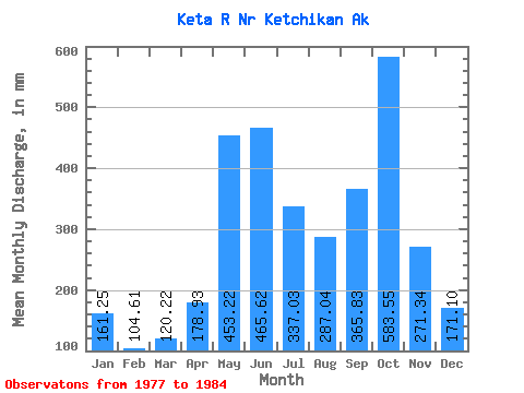
| Statistic | Jan | Feb | Mar | Apr | May | Jun | Jul | Aug | Sep | Oct | Nov | Dec | Annual |
|---|---|---|---|---|---|---|---|---|---|---|---|---|---|
| Mean | 161.22 | 105.50 | 120.21 | 178.93 | 453.16 | 465.62 | 336.99 | 287.01 | 365.84 | 583.46 | 271.33 | 171.07 | 3486.26 |
| Standard Deviation | 115.54 | 58.14 | 65.21 | 63.04 | 89.69 | 137.26 | 105.44 | 116.24 | 197.31 | 215.05 | 153.72 | 164.03 | 452.01 |
| Min | 54.16 | 29.31 | 38.02 | 86.37 | 317.60 | 372.52 | 224.55 | 161.97 | 140.78 | 304.76 | 99.10 | 31.95 | 2991.00 |
| Max | 371.27 | 183.34 | 215.68 | 269.33 | 577.79 | 758.41 | 543.05 | 455.86 | 816.73 | 876.04 | 461.07 | 422.88 | 4136.86 |
| Coefficient of Variation | 0.72 | 0.55 | 0.54 | 0.35 | 0.20 | 0.29 | 0.31 | 0.41 | 0.54 | 0.37 | 0.57 | 0.96 | 0.13 |
 Return to R-Arctic Net Home Page