|
|
|||||||||||||||||
| Point ID: 9263 | Downloads | Plots | Site Data | Code: 15011500 |
|
|
|||||||||||||||||
| Download | |
|---|---|
| Site Descriptor Information | Site Time Series Data |
| Link to all available data | |
| View: | Time Series | All |
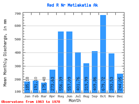
| Units: | m3/s |
| Statistic | Jan | Feb | Mar | Apr | May | Jun | Jul | Aug | Sep | Oct | Nov | Dec | Annual |
|---|---|---|---|---|---|---|---|---|---|---|---|---|---|
| Mean | 185.16 | 192.75 | 175.46 | 273.63 | 556.32 | 557.08 | 401.71 | 319.95 | 409.87 | 679.62 | 393.52 | 244.01 | 4428.53 |
| Standard Deviation | 128.99 | 118.41 | 113.69 | 68.74 | 126.72 | 148.56 | 144.56 | 156.19 | 188.37 | 201.43 | 206.00 | 143.27 | 634.07 |
| Min | 32.32 | 26.61 | 58.23 | 154.24 | 327.20 | 219.73 | 153.37 | 104.56 | 83.78 | 290.69 | 65.33 | 70.07 | 3547.84 |
| Max | 487.24 | 416.72 | 385.51 | 401.59 | 760.83 | 817.49 | 688.77 | 679.85 | 788.68 | 1168.99 | 941.15 | 477.50 | 5628.48 |
| Coefficient of Variation | 0.70 | 0.61 | 0.65 | 0.25 | 0.23 | 0.27 | 0.36 | 0.49 | 0.46 | 0.30 | 0.52 | 0.59 | 0.14 |
 Return to R-Arctic Net Home Page