|
|
|||||||||||||||||
| Point ID: 9249 | Downloads | Plots | Site Data | Code: 15031000 |
|
|
|||||||||||||||||
| Download | |
|---|---|
| Site Descriptor Information | Site Time Series Data |
| Link to all available data | |
| View: | Time Series | All |
| Units: | m3/s |
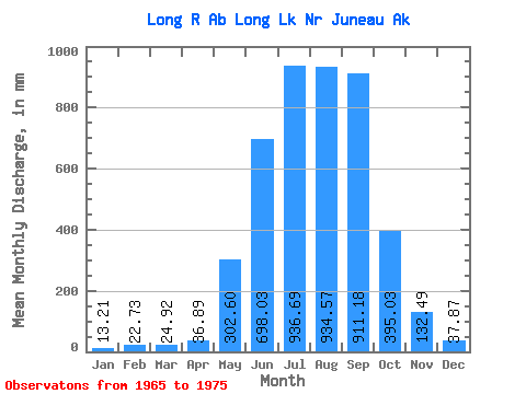
| Statistic | Jan | Feb | Mar | Apr | May | Jun | Jul | Aug | Sep | Oct | Nov | Dec | Annual |
|---|---|---|---|---|---|---|---|---|---|---|---|---|---|
| Mean | 13.22 | 22.98 | 24.94 | 36.95 | 302.53 | 698.06 | 936.50 | 934.45 | 911.15 | 395.02 | 132.46 | 37.86 | 4364.68 |
| Standard Deviation | 7.94 | 39.29 | 39.15 | 19.21 | 81.47 | 219.03 | 248.30 | 180.86 | 561.59 | 237.31 | 90.65 | 24.19 | 965.37 |
| Min | 3.56 | 1.37 | 0.00 | 7.51 | 162.57 | 373.92 | 574.21 | 645.67 | 396.35 | 195.81 | 29.82 | 15.69 | 2692.66 |
| Max | 27.70 | 131.21 | 132.30 | 82.84 | 441.11 | 1059.20 | 1334.14 | 1224.24 | 2353.49 | 939.92 | 326.94 | 81.69 | 6462.12 |
| Coefficient of Variation | 0.60 | 1.71 | 1.57 | 0.52 | 0.27 | 0.31 | 0.27 | 0.19 | 0.62 | 0.60 | 0.68 | 0.64 | 0.22 |
 Return to R-Arctic Net Home Page