|
|
|||||||||||||||||
| Point ID: 9243 | Downloads | Plots | Site Data | Code: 15041200 |
|
|
|||||||||||||||||
| Download | |
|---|---|
| Site Descriptor Information | Site Time Series Data |
| Link to all available data | |
| View: | Time Series | All |
| Units: | m3/s |
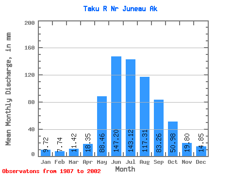
| Statistic | Jan | Feb | Mar | Apr | May | Jun | Jul | Aug | Sep | Oct | Nov | Dec | Annual |
|---|---|---|---|---|---|---|---|---|---|---|---|---|---|
| Mean | 9.72 | 7.81 | 11.42 | 18.35 | 88.44 | 147.20 | 143.10 | 117.30 | 83.26 | 50.97 | 19.80 | 14.85 | 708.94 |
| Standard Deviation | 3.88 | 2.54 | 10.05 | 5.83 | 30.01 | 27.58 | 23.37 | 19.38 | 19.96 | 16.05 | 7.09 | 5.93 | 101.23 |
| Min | 4.99 | 4.21 | 6.03 | 8.03 | 42.82 | 99.49 | 111.08 | 82.57 | 48.01 | 27.79 | 10.68 | 5.57 | 543.89 |
| Max | 18.73 | 14.88 | 46.57 | 29.26 | 149.93 | 211.58 | 182.24 | 147.85 | 114.00 | 76.54 | 37.07 | 29.34 | 834.61 |
| Coefficient of Variation | 0.40 | 0.33 | 0.88 | 0.32 | 0.34 | 0.19 | 0.16 | 0.17 | 0.24 | 0.32 | 0.36 | 0.40 | 0.14 |
 Return to R-Arctic Net Home Page