|
|
|||||||||||||||||
| Point ID: 9238 | Downloads | Plots | Site Data | Code: 15081497 |
|
|
|||||||||||||||||
| Download | |
|---|---|
| Site Descriptor Information | Site Time Series Data |
| Link to all available data | |
| View: | Time Series | All |
| Units: | m3/s |
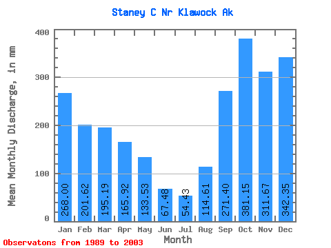
| Statistic | Jan | Feb | Mar | Apr | May | Jun | Jul | Aug | Sep | Oct | Nov | Dec | Annual |
|---|---|---|---|---|---|---|---|---|---|---|---|---|---|
| Mean | 267.96 | 203.36 | 195.16 | 165.92 | 133.50 | 67.47 | 54.42 | 114.61 | 271.40 | 381.09 | 311.68 | 342.30 | 2492.57 |
| Standard Deviation | 96.50 | 139.78 | 77.03 | 65.62 | 75.38 | 31.91 | 29.69 | 79.76 | 114.82 | 115.63 | 133.56 | 175.07 | 555.18 |
| Min | 138.69 | 80.05 | 60.14 | 80.60 | 45.70 | 14.82 | 12.79 | 15.40 | 93.22 | 233.03 | 112.62 | 154.27 | 1697.00 |
| Max | 452.60 | 518.21 | 326.87 | 313.05 | 322.88 | 140.97 | 115.90 | 271.47 | 503.03 | 649.54 | 557.80 | 734.61 | 3628.45 |
| Coefficient of Variation | 0.36 | 0.69 | 0.40 | 0.40 | 0.56 | 0.47 | 0.55 | 0.70 | 0.42 | 0.30 | 0.43 | 0.51 | 0.22 |
 Return to R-Arctic Net Home Page