|
|
|||||||||||||||||
| Point ID: 9232 | Downloads | Plots | Site Data | Code: 15086500 |
|
|
|||||||||||||||||
| Download | |
|---|---|
| Site Descriptor Information | Site Time Series Data |
| Link to all available data | |
| View: | Time Series | All |
| Units: | m3/s |
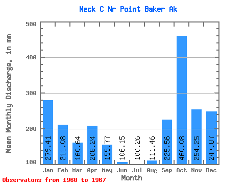
| Statistic | Jan | Feb | Mar | Apr | May | Jun | Jul | Aug | Sep | Oct | Nov | Dec | Annual |
|---|---|---|---|---|---|---|---|---|---|---|---|---|---|
| Mean | 279.35 | 212.87 | 160.59 | 208.23 | 155.75 | 106.17 | 100.27 | 111.47 | 225.57 | 460.00 | 254.28 | 247.81 | 2448.42 |
| Standard Deviation | 138.50 | 90.47 | 34.25 | 70.45 | 85.11 | 43.87 | 50.43 | 66.51 | 120.25 | 168.52 | 91.68 | 75.64 | 328.52 |
| Min | 88.06 | 88.72 | 89.29 | 110.93 | 49.37 | 42.65 | 41.57 | 11.23 | 29.32 | 272.81 | 115.10 | 156.72 | 2064.61 |
| Max | 499.30 | 379.91 | 184.30 | 273.52 | 290.77 | 163.70 | 196.71 | 197.75 | 439.77 | 777.79 | 384.51 | 373.83 | 2921.39 |
| Coefficient of Variation | 0.50 | 0.42 | 0.21 | 0.34 | 0.55 | 0.41 | 0.50 | 0.60 | 0.53 | 0.37 | 0.36 | 0.30 | 0.13 |
 Return to R-Arctic Net Home Page