|
|
|||||||||||||||||
| Point ID: 9224 | Downloads | Plots | Site Data | Code: 15212000 |
|
|
|||||||||||||||||
| Download | |
|---|---|
| Site Descriptor Information | Site Time Series Data |
| Link to all available data | |
| View: | Time Series | All |
| Units: | m3/s |
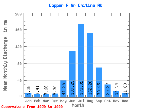
| Statistic | Jan | Feb | Mar | Apr | May | Jun | Jul | Aug | Sep | Oct | Nov | Dec | Annual |
|---|---|---|---|---|---|---|---|---|---|---|---|---|---|
| Mean | 9.38 | 7.47 | 7.68 | 9.30 | 41.26 | 109.25 | 173.89 | 152.18 | 70.45 | 30.36 | 14.94 | 10.99 | 630.88 |
| Standard Deviation | 2.99 | 2.45 | 2.58 | 4.44 | 12.49 | 25.68 | 21.53 | 30.00 | 19.74 | 7.21 | 4.70 | 2.95 | 74.54 |
| Min | 3.84 | 2.98 | 2.84 | 4.13 | 21.89 | 66.10 | 119.99 | 75.84 | 38.43 | 19.41 | 8.25 | 6.25 | 443.54 |
| Max | 16.96 | 15.40 | 16.23 | 26.64 | 70.99 | 158.16 | 224.89 | 228.47 | 131.47 | 48.62 | 28.16 | 19.99 | 826.54 |
| Coefficient of Variation | 0.32 | 0.33 | 0.34 | 0.48 | 0.30 | 0.23 | 0.12 | 0.20 | 0.28 | 0.24 | 0.32 | 0.27 | 0.12 |
 Return to R-Arctic Net Home Page