|
|
|||||||||||||||||
| Point ID: 9214 | Downloads | Plots | Site Data | Code: 15200000 |
|
|
|||||||||||||||||
| Download | |
|---|---|
| Site Descriptor Information | Site Time Series Data |
| Link to all available data | |
| View: | Time Series | All |
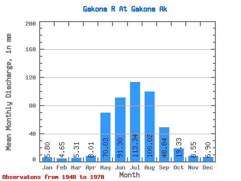
| Units: | m3/s |
| Statistic | Jan | Feb | Mar | Apr | May | Jun | Jul | Aug | Sep | Oct | Nov | Dec | Annual |
|---|---|---|---|---|---|---|---|---|---|---|---|---|---|
| Mean | 5.80 | 4.69 | 5.31 | 8.01 | 70.02 | 91.30 | 113.32 | 100.00 | 48.84 | 19.32 | 8.55 | 6.90 | 490.45 |
| Standard Deviation | 3.31 | 2.64 | 3.15 | 4.95 | 32.33 | 32.22 | 23.05 | 26.50 | 23.18 | 8.42 | 4.33 | 3.75 | 94.70 |
| Min | 2.31 | 1.85 | 2.17 | 2.91 | 17.17 | 42.78 | 60.82 | 38.03 | 20.02 | 8.55 | 3.27 | 2.46 | 293.39 |
| Max | 13.22 | 11.19 | 11.81 | 20.52 | 157.97 | 179.25 | 168.65 | 152.96 | 120.09 | 37.29 | 17.67 | 14.17 | 726.69 |
| Coefficient of Variation | 0.57 | 0.56 | 0.59 | 0.62 | 0.46 | 0.35 | 0.20 | 0.27 | 0.47 | 0.44 | 0.51 | 0.54 | 0.19 |
 Return to R-Arctic Net Home Page