|
|
|||||||||||||||||
| Point ID: 9173 | Downloads | Plots | Site Data | Code: 15087590 |
|
|
|||||||||||||||||
| Download | |
|---|---|
| Site Descriptor Information | Site Time Series Data |
| Link to all available data | |
| View: | Time Series | All |
| Units: | m3/s |
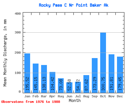
| Statistic | Jan | Feb | Mar | Apr | May | Jun | Jul | Aug | Sep | Oct | Nov | Dec | Annual |
|---|---|---|---|---|---|---|---|---|---|---|---|---|---|
| Mean | 195.66 | 146.42 | 137.99 | 104.54 | 72.96 | 52.60 | 54.84 | 87.79 | 173.34 | 300.71 | 191.97 | 179.24 | 1688.94 |
| Standard Deviation | 138.21 | 100.48 | 80.75 | 56.70 | 40.54 | 37.08 | 46.80 | 66.08 | 120.90 | 156.49 | 88.83 | 97.65 | 438.02 |
| Min | 37.12 | 8.90 | 48.29 | 16.53 | 14.46 | 2.25 | 14.92 | 3.86 | 53.91 | 103.69 | 82.67 | 32.83 | 1162.52 |
| Max | 416.62 | 326.97 | 327.28 | 193.78 | 139.13 | 122.34 | 174.07 | 215.10 | 449.89 | 602.72 | 368.90 | 355.83 | 2386.61 |
| Coefficient of Variation | 0.71 | 0.69 | 0.58 | 0.54 | 0.56 | 0.70 | 0.85 | 0.75 | 0.70 | 0.52 | 0.46 | 0.55 | 0.26 |
 Return to R-Arctic Net Home Page