|
|
|||||||||||||||||
| Point ID: 9162 | Downloads | Plots | Site Data | Code: 15129500 |
|
|
|||||||||||||||||
| Download | |
|---|---|
| Site Descriptor Information | Site Time Series Data |
| Link to all available data | |
| View: | Time Series | All |
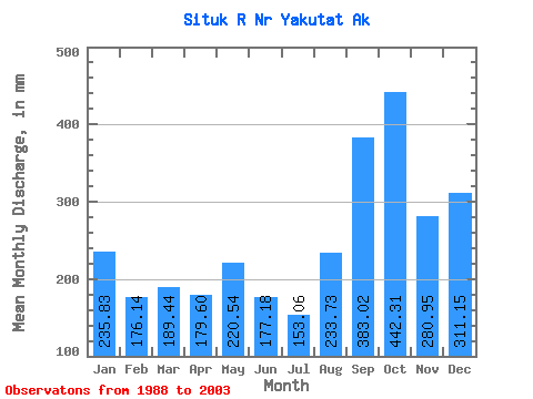
| Units: | m3/s |
| Statistic | Jan | Feb | Mar | Apr | May | Jun | Jul | Aug | Sep | Oct | Nov | Dec | Annual |
|---|---|---|---|---|---|---|---|---|---|---|---|---|---|
| Mean | 235.79 | 177.67 | 189.41 | 179.59 | 220.51 | 177.19 | 153.04 | 233.68 | 383.01 | 442.25 | 280.94 | 311.09 | 2991.43 |
| Standard Deviation | 110.39 | 83.05 | 105.80 | 64.47 | 64.13 | 47.62 | 46.51 | 125.74 | 134.14 | 153.44 | 107.92 | 163.87 | 477.80 |
| Min | 106.28 | 60.18 | 44.09 | 57.99 | 130.53 | 99.96 | 63.24 | 85.51 | 205.39 | 230.24 | 136.48 | 115.17 | 2140.02 |
| Max | 504.44 | 349.01 | 419.90 | 291.75 | 340.42 | 271.59 | 237.46 | 498.19 | 660.13 | 714.47 | 471.10 | 601.37 | 3826.36 |
| Coefficient of Variation | 0.47 | 0.47 | 0.56 | 0.36 | 0.29 | 0.27 | 0.30 | 0.54 | 0.35 | 0.35 | 0.38 | 0.53 | 0.16 |
 Return to R-Arctic Net Home Page