|
|
|||||||||||||||||
| Point ID: 9105 | Downloads | Plots | Site Data | Code: 15493000 |
|
|
|||||||||||||||||
| Download | |
|---|---|
| Site Descriptor Information | Site Time Series Data |
| Link to all available data | |
| View: | Time Series | All |
| Units: | m3/s |
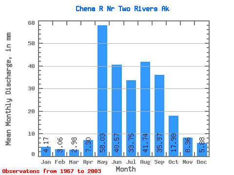
| Statistic | Jan | Feb | Mar | Apr | May | Jun | Jul | Aug | Sep | Oct | Nov | Dec | Annual |
|---|---|---|---|---|---|---|---|---|---|---|---|---|---|
| Mean | 4.17 | 3.08 | 2.98 | 7.30 | 58.02 | 40.57 | 33.74 | 41.73 | 35.97 | 17.98 | 8.36 | 5.88 | 256.00 |
| Standard Deviation | 1.46 | 1.35 | 1.16 | 5.48 | 29.04 | 23.62 | 16.09 | 20.59 | 19.74 | 9.45 | 3.35 | 2.02 | 75.82 |
| Min | 1.19 | 0.57 | 0.68 | 2.06 | 19.52 | 9.77 | 11.88 | 13.67 | 13.76 | 8.12 | 3.64 | 2.67 | 137.57 |
| Max | 7.57 | 7.02 | 5.36 | 27.58 | 131.56 | 122.12 | 78.28 | 100.20 | 82.85 | 51.74 | 18.67 | 11.52 | 404.17 |
| Coefficient of Variation | 0.35 | 0.44 | 0.39 | 0.75 | 0.50 | 0.58 | 0.48 | 0.49 | 0.55 | 0.53 | 0.40 | 0.34 | 0.30 |
 Return to R-Arctic Net Home Page