|
|
|||||||||||||||||
| Point ID: 9101 | Downloads | Plots | Site Data | Code: 127.6.0.1001.2 |
|
|
|||||||||||||||||
| Download | |
|---|---|
| Site Descriptor Information | Site Time Series Data |
| Link to all available data | |
| View: | Time Series | All |
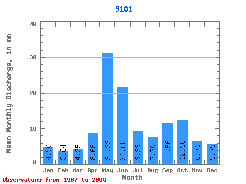
| Units: | m3/s |
| Statistic | Jan | Feb | Mar | Apr | May | Jun | Jul | Aug | Sep | Oct | Nov | Dec | Annual |
|---|---|---|---|---|---|---|---|---|---|---|---|---|---|
| Mean | 49.64 | 37.18 | 43.05 | 88.02 | 316.39 | 219.68 | 95.18 | 78.03 | 117.14 | 127.43 | 68.04 | 58.27 | 1297.95 |
| Standard Deviation | 52.32 | 37.46 | 54.11 | 49.40 | 82.82 | 90.81 | 48.39 | 53.53 | 67.07 | 74.61 | 50.91 | 50.25 | 263.85 |
| Min | 5.01 | 4.40 | 4.42 | 12.89 | 144.33 | 63.95 | 17.44 | 6.66 | 11.98 | 17.71 | 7.40 | 4.58 | 789.55 |
| Max | 273.47 | 190.44 | 333.28 | 208.64 | 485.15 | 430.64 | 234.83 | 259.39 | 362.13 | 357.90 | 227.89 | 249.89 | 1929.91 |
| Coefficient of Variation | 1.05 | 1.01 | 1.26 | 0.56 | 0.26 | 0.41 | 0.51 | 0.69 | 0.57 | 0.59 | 0.75 | 0.86 | 0.20 |
 Return to R-Arctic Net Home Page