|
|
|||||||||||||||||
| Point ID: 9098 | Downloads | Plots | Site Data | Code: 15747000 |
|
|
|||||||||||||||||
| Download | |
|---|---|
| Site Descriptor Information | Site Time Series Data |
| Link to all available data | |
| View: | Time Series | All |
| Units: | m3/s |
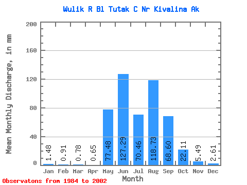
| Statistic | Jan | Feb | Mar | Apr | May | Jun | Jul | Aug | Sep | Oct | Nov | Dec | Annual |
|---|---|---|---|---|---|---|---|---|---|---|---|---|---|
| Mean | 1.48 | 0.92 | 0.78 | 0.65 | 77.47 | 127.29 | 70.45 | 118.72 | 68.60 | 22.11 | 5.49 | 2.61 | 499.80 |
| Standard Deviation | 0.60 | 0.42 | 0.38 | 0.31 | 68.39 | 57.90 | 62.76 | 86.26 | 34.36 | 15.87 | 2.50 | 1.05 | 177.44 |
| Min | 0.90 | 0.45 | 0.38 | 0.36 | 0.85 | 55.13 | 17.62 | 20.59 | 15.51 | 8.58 | 2.54 | 1.42 | 257.11 |
| Max | 2.91 | 1.86 | 1.64 | 1.56 | 201.66 | 268.09 | 255.15 | 351.29 | 123.66 | 64.04 | 11.68 | 4.59 | 903.86 |
| Coefficient of Variation | 0.41 | 0.45 | 0.48 | 0.48 | 0.88 | 0.46 | 0.89 | 0.73 | 0.50 | 0.72 | 0.46 | 0.40 | 0.35 |
 Return to R-Arctic Net Home Page