|
|
|||||||||||||||||
| Point ID: 9096 | Downloads | Plots | Site Data | Code: 15565700 |
|
|
|||||||||||||||||
| Download | |
|---|---|
| Site Descriptor Information | Site Time Series Data |
| Link to all available data | |
| View: | Time Series | All |
| Units: | m3/s |
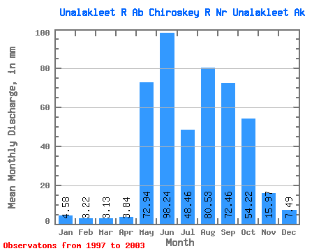
| Statistic | Jan | Feb | Mar | Apr | May | Jun | Jul | Aug | Sep | Oct | Nov | Dec | Annual |
|---|---|---|---|---|---|---|---|---|---|---|---|---|---|
| Mean | 4.58 | 3.25 | 3.13 | 3.84 | 72.93 | 98.24 | 48.45 | 80.52 | 72.45 | 54.21 | 15.97 | 7.49 | 446.57 |
| Standard Deviation | 0.68 | 0.33 | 0.32 | 1.69 | 33.22 | 66.59 | 20.77 | 40.91 | 25.05 | 25.55 | 4.97 | 1.67 | 74.31 |
| Min | 4.12 | 2.96 | 2.74 | 2.83 | 33.02 | 32.87 | 15.69 | 22.59 | 37.46 | 28.98 | 10.64 | 5.54 | 375.45 |
| Max | 5.59 | 3.70 | 3.44 | 6.37 | 113.23 | 237.63 | 71.84 | 158.96 | 105.19 | 96.95 | 21.57 | 9.56 | 523.71 |
| Coefficient of Variation | 0.15 | 0.10 | 0.10 | 0.44 | 0.46 | 0.68 | 0.43 | 0.51 | 0.35 | 0.47 | 0.31 | 0.22 | 0.17 |
 Return to R-Arctic Net Home Page