|
|
|||||||||||||||||
| Point ID: 9076 | Downloads | Plots | Site Data | Code: 49127 |
|
|
|||||||||||||||||
| Download | |
|---|---|
| Site Descriptor Information | Site Time Series Data |
| Link to all available data | |
| View: | Time Series | All |
| Units: | m3/s |
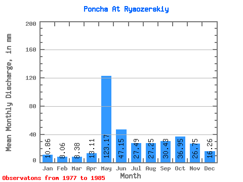
| Statistic | Jan | Feb | Mar | Apr | May | Jun | Jul | Aug | Sep | Oct | Nov | Dec | Annual |
|---|---|---|---|---|---|---|---|---|---|---|---|---|---|
| Mean | 10.86 | 8.13 | 8.38 | 13.11 | 123.15 | 47.15 | 27.49 | 27.25 | 30.43 | 36.95 | 26.75 | 16.25 | 373.77 |
| Standard Deviation | 3.44 | 2.89 | 2.88 | 13.30 | 36.23 | 25.82 | 10.58 | 14.31 | 15.26 | 13.06 | 10.26 | 4.02 | 80.15 |
| Min | 6.14 | 3.79 | 3.79 | 4.81 | 66.95 | 17.80 | 9.64 | 7.95 | 7.37 | 20.86 | 11.54 | 9.16 | 208.16 |
| Max | 16.52 | 12.13 | 12.77 | 47.35 | 194.60 | 91.15 | 42.67 | 49.29 | 59.10 | 62.90 | 45.93 | 21.45 | 486.40 |
| Coefficient of Variation | 0.32 | 0.35 | 0.34 | 1.01 | 0.29 | 0.55 | 0.39 | 0.53 | 0.50 | 0.35 | 0.38 | 0.25 | 0.21 |
 Return to R-Arctic Net Home Page