|
|
|||||||||||||||||
| Point ID: 9075 | Downloads | Plots | Site Data | Code: 49122 |
|
|
|||||||||||||||||
| Download | |
|---|---|
| Site Descriptor Information | Site Time Series Data |
| Link to all available data | |
| View: | Time Series | All |
| Units: | m3/s |
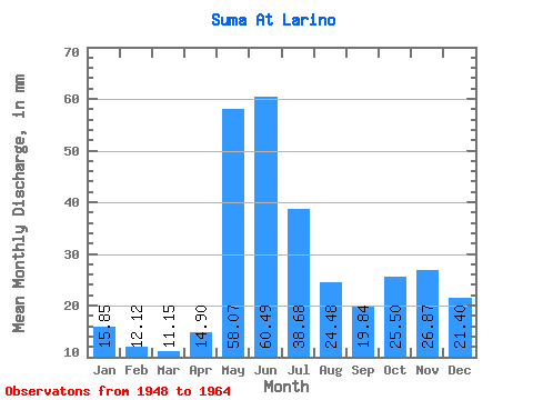
| Statistic | Jan | Feb | Mar | Apr | May | Jun | Jul | Aug | Sep | Oct | Nov | Dec | Annual |
|---|---|---|---|---|---|---|---|---|---|---|---|---|---|
| Mean | 15.84 | 12.22 | 11.15 | 14.90 | 58.06 | 60.49 | 38.67 | 24.47 | 19.84 | 25.50 | 26.87 | 21.39 | 331.43 |
| Standard Deviation | 6.92 | 4.71 | 3.89 | 7.34 | 23.17 | 26.04 | 14.10 | 12.51 | 11.85 | 15.11 | 14.93 | 10.81 | 103.59 |
| Min | 0.00 | 0.00 | 0.00 | 6.61 | 12.31 | 18.43 | 15.63 | 7.83 | 4.43 | 6.14 | 6.53 | 3.65 | 172.62 |
| Max | 29.88 | 18.90 | 15.94 | 29.52 | 104.02 | 109.37 | 69.81 | 52.94 | 41.95 | 59.91 | 62.33 | 43.50 | 536.26 |
| Coefficient of Variation | 0.44 | 0.39 | 0.35 | 0.49 | 0.40 | 0.43 | 0.36 | 0.51 | 0.60 | 0.59 | 0.56 | 0.51 | 0.31 |
 Return to R-Arctic Net Home Page