|
|
|||||||||||||||||
| Point ID: 9055 | Downloads | Plots | Site Data | Code: 49046 |
|
|
|||||||||||||||||
| Download | |
|---|---|
| Site Descriptor Information | Site Time Series Data |
| Link to all available data | |
| View: | Time Series | All |
| Units: | m3/s |
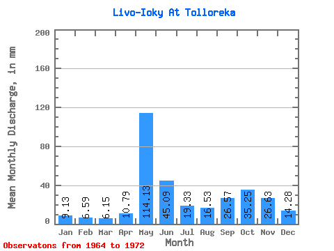
| Statistic | Jan | Feb | Mar | Apr | May | Jun | Jul | Aug | Sep | Oct | Nov | Dec | Annual |
|---|---|---|---|---|---|---|---|---|---|---|---|---|---|
| Mean | 9.13 | 6.64 | 6.15 | 10.79 | 114.11 | 45.08 | 19.33 | 16.53 | 26.57 | 35.25 | 26.62 | 14.28 | 333.32 |
| Standard Deviation | 1.97 | 2.02 | 1.04 | 6.99 | 24.27 | 11.37 | 9.29 | 8.76 | 13.75 | 11.81 | 12.71 | 3.45 | 31.08 |
| Min | 5.43 | 4.34 | 4.10 | 4.84 | 83.10 | 25.16 | 11.03 | 4.88 | 13.80 | 22.02 | 13.19 | 10.87 | 295.45 |
| Max | 12.68 | 10.69 | 7.37 | 23.10 | 146.90 | 60.23 | 37.57 | 32.53 | 54.89 | 53.17 | 49.17 | 21.42 | 373.34 |
| Coefficient of Variation | 0.22 | 0.30 | 0.17 | 0.65 | 0.21 | 0.25 | 0.48 | 0.53 | 0.52 | 0.34 | 0.48 | 0.24 | 0.09 |
 Return to R-Arctic Net Home Page