|
|
|||||||||||||||||
| Point ID: 9041 | Downloads | Plots | Site Data | Code: 71284 |
|
|
|||||||||||||||||
| Download | |
|---|---|
| Site Descriptor Information | Site Time Series Data |
| Link to all available data | |
| View: | Time Series | All |
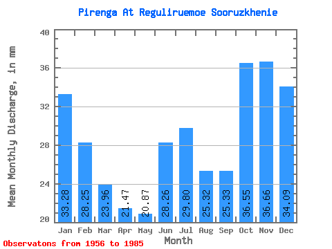
| Units: | m3/s |
| Statistic | Jan | Feb | Mar | Apr | May | Jun | Jul | Aug | Sep | Oct | Nov | Dec | Annual |
|---|---|---|---|---|---|---|---|---|---|---|---|---|---|
| Mean | 33.28 | 28.49 | 23.95 | 21.47 | 20.86 | 28.26 | 29.80 | 25.32 | 25.33 | 36.54 | 36.66 | 34.09 | 344.25 |
| Standard Deviation | 14.32 | 13.61 | 10.27 | 9.97 | 9.36 | 18.47 | 15.64 | 11.78 | 9.69 | 14.38 | 16.59 | 15.65 | 71.25 |
| Min | 11.94 | 9.05 | 0.06 | 6.08 | 3.92 | 0.00 | 1.56 | 4.95 | 4.69 | 3.72 | 4.78 | 6.29 | 189.76 |
| Max | 69.15 | 61.29 | 43.75 | 45.02 | 41.62 | 66.32 | 66.01 | 68.52 | 50.87 | 71.04 | 61.45 | 62.05 | 453.52 |
| Coefficient of Variation | 0.43 | 0.48 | 0.43 | 0.46 | 0.45 | 0.65 | 0.53 | 0.47 | 0.38 | 0.39 | 0.45 | 0.46 | 0.21 |
 Return to R-Arctic Net Home Page