|
|
|||||||||||||||||
| Point ID: 9039 | Downloads | Plots | Site Data | Code: 71277 |
|
|
|||||||||||||||||
| Download | |
|---|---|
| Site Descriptor Information | Site Time Series Data |
| Link to all available data | |
| View: | Time Series | All |
| Units: | m3/s |
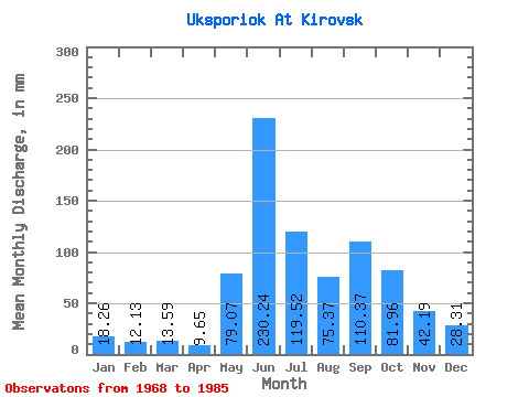
| Statistic | Jan | Feb | Mar | Apr | May | Jun | Jul | Aug | Sep | Oct | Nov | Dec | Annual |
|---|---|---|---|---|---|---|---|---|---|---|---|---|---|
| Mean | 18.27 | 12.24 | 13.58 | 9.68 | 79.08 | 230.23 | 119.53 | 75.35 | 110.39 | 81.94 | 42.20 | 28.33 | 834.11 |
| Standard Deviation | 6.81 | 4.25 | 13.65 | 3.35 | 72.24 | 65.03 | 37.56 | 20.93 | 40.65 | 31.15 | 12.52 | 8.86 | 119.03 |
| Min | 8.85 | 6.30 | 5.15 | 5.84 | 16.89 | 120.65 | 69.16 | 43.43 | 51.37 | 33.78 | 21.80 | 14.48 | 665.32 |
| Max | 31.36 | 23.45 | 66.75 | 19.46 | 254.93 | 373.62 | 192.21 | 113.39 | 175.13 | 131.09 | 60.71 | 45.03 | 1147.25 |
| Coefficient of Variation | 0.37 | 0.35 | 1.00 | 0.35 | 0.91 | 0.28 | 0.31 | 0.28 | 0.37 | 0.38 | 0.30 | 0.31 | 0.14 |
 Return to R-Arctic Net Home Page